Let’s be straight– There is NO right answer to this question. The “best” always depends on your project requirements and mission parameters. So, let’s discuss where and when LiDAR outshines Photogrammetry and vice versa.
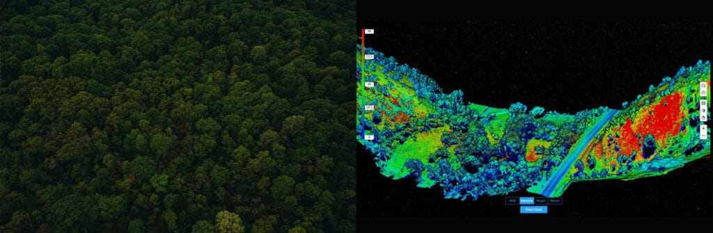
LiDAR stands for Light Detection and Ranging, and LiDAR uses laser pulses to calculate an object’s variable distances from the earth’s surface. To be precise, LiDAR works by sending light pulses to the earth’s surface, and the amount of time it takes to return to the source indicates the exact distance of the object (which is known as the Time-of-Flight principle). Likewise, LIDAR can be used in archaeology, climate monitoring, urban planning, mining, the energy sector and more.
According to photogrammetry.com, “photogrammetry is the science of making measurements from photographs”. In the Photogrammetry technique, high-resolution photographs are captured to recreate the survey area into realistic, georeferenced 3D models, 2D maps and much more. The photogrammetry technique has a wide range of applications, including project management, crime-scene mapping, marketing, topographical mapping, facade inspections and more.
DJI’s first Livox LiDAR payload — the DJI Zenmuse L1, is gaining a lot of traction among drone professionals. First of all, the DJI Zenmuse L1 incorporates the powers of both laser and visible light; this payload can simultaneously capture both LiDAR and Photogrammetry data. L1 integrates a Livox LiDAR module, a high-accuracy IMU, a 20MP survey-grade camera, and it comes with a 3-axis stabilized gimbal. Well, not just that, there is a lot more to explore about this unparalleled payload in Drone-based Lidar solutions.

The DJI Zenmuse P1 is a photogrammetry tool that every drone professional will confidently vouch for. P1 has a lot of exciting features to explore, including a 45MP full-frame sensor, interchangeable fixed focal lenses, Global Mechanical Shutter, the Smart Oblique Capture function and much more.

Both Zenmuse L1 and P1 work in conjunction with the DJI M300 RTK and the Planning & Processing software – DJI Terra. Together it provides an exclusive end-to-end solution to our drone-based operations. Under this ecosystem of DJI solutions, you will never have to worry about compatibility issues.
Now let’s have a quick comparison between the two data-capturing techniques based on the following criteria:
Accuracy: When your main priority is accuracy, LiDAR reigns supreme. In the Lidar method, we get direct measurements by firing laser pulses to the earth’s surface. Additionally, its integration with GNSS data makes it an ideal solution to achieve absolute accuracy.
This is not to say that Photogrammetry is not an accurate survey solution. Photogrammetry is also accurate; however, to achieve this accuracy, the quality of the drone and payload are equally important. In addition, the sensor size really matters in Photogrammetry; that being said, DJI’s Zenmuse P1 has a full-frame sensor with the highest possible resolution.
GSD is a significant factor for effective data processing – the sensor size, resolution, focal length, and so on may affect ground sample distance (GSD). This is also where LiDAR gains the advantage over Photogrammetry; LiDAR does not require GCPs to obtain accurate data.
Efficiency: One of the major advantages of using LiDAR over Photogrammetry is its high-end performance in certain critical missions, such as in survey areas with a complex vegetation cover. LiDAR pulses’ ability to penetrate through the leaves and branches to reach the ground level makes it exceptional when obtaining bare earth models.
Likewise, Lidar is also better for missions that take place in low-light conditions or even at night. With LiDAR, you don’t need an external light source to carry out night missions. On the other hand, when it comes to Photogrammetry, low light, shadows, reflective surfaces, or dust can adversely impact data capturing and accuracy.
Ease of use and Pricing: Compared to photogrammetry methods, LiDAR is more complex and requires in-depth knowledge to operate and generate effective results. This opens room for error and increases the demand for an experienced drone pilot. On the other hand, Photogrammetry is a more straightforward data-capturing method. But that being said, it is to be noted that the DJI Zenmuse L1 is an exception. L1 is designed in such a way that it simplifies the LiDAR workflow and makes the operations more accessible.
Now the cost factor; traditionally, LiDAR uses lasers that are large enough to demand a more extensive transportation system like helicopters and so on. It is quite evident that Photogrammetry is a more affordable solution than LiDAR. However, the DJI Zenmuse L1 is a more cost-effective and compact solution than other LiDAR payloads available on the market.
If you think it is not a good idea to compare LiDAR and Photogrammetry as two competing data-capture methodologies, great! One doesn’t outshine the other; it is all about your requirements. For instance, if the contrast, lighting, subject, and conditions are all ideal, then Photogrammetry would be the right choice. But, on the other hand, for challenging missions where elevation accuracy, complex structures, intricate objects, or difficult terrain are involved, you should go for LiDAR.
Other important factors you may have to consider are, of course, the budget and experience of your team. Thankfully we won’t have to worry too much about the cost, as DJI’s Zenmuse P1 and Zenmuse L1 payloads are priced extremely competitively.
We would suggest that the right way to go about it is to be knowledgeable about both the data-capturing methodologies and become adept at utilizing both technologies with respect to your requirements.