Drone surveying is a huge business, and that’s when drone professionals’ favourite photogrammetry tool comes into the picture – The DJI Zenmuse P1. There are a lot of exciting features to explore on P1, including a full-frame sensor, interchangeable lenses, the Smart Oblique Capture function and more. However, you might also wonder how is P1 performing compared to other players like DJI Phantom 4RTK. Well, to begin with, the DJI Zemuse P1’s sensor is 7.5 times larger than the Phantom 4 RTK. The P1 also collects data five times faster than the DJI Phantom 4 RTK; in a given time, P1 covers more area – 4.3 times than the P4 RTK can.
If you already own a P4 RTK, I hope you would want to switch to the DJI Zenmuse P1 for its undeniable advantages over other players in the market.
It’s hard to believe that these images are from the same location.

The one on the right; with the absence of texture, it seems to blend and form one smooth homogenous surface. Unfortunately, homogeneous surfaces spell disaster for post-processing software — due to the insufficient tie-points, the processing software can generate only a sparse point cloud which brings down the accuracy of the data set.
Unfortunately, the secrets of the desert would remain locked— until the release of DJI’s first-ever full-frame sensor – the Zenmuse P1.

Look at the details and textures. Now we see ripples in the sand, small shrubs and even twigs – thanks to the DJI Zenmuse P1. Likewise, P1 will help us plan for large scale expansions, design grand architectural marvels and explore the unexplored.
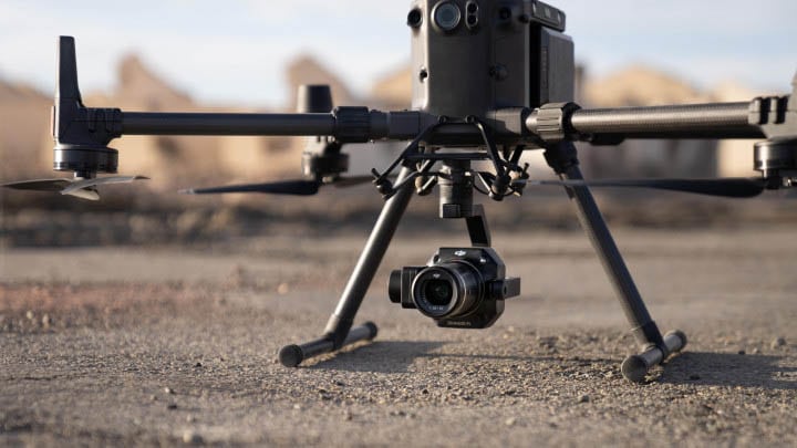
A robust sensor with interchangeable lenses
The Zenmuse P1 is a powerful DJI payload compatible with DJI’s M300 RTK. with a 45-megapixel camera integrated with a full-frame, low-noise, high-sensitivity sensor. The P1 is DJI’s largest image sensor with the highest resolution. That being said, the Phantom 4 RTK has a 20MP sensor, which is 7.5 times small than the DJI Zemuse P1.
In addition, this payload comes with three interchangeable fixed focused lenses – 24/35/50mm, supported by a 3-axis stabilised gimbal, giving us the flexibility to choose the specific Field of View – 84°, 63.5° and 46.8° respectively.
Unbeatable speed and efficiency
The P1’s new global shutter can achieve speeds of 1/2000 seconds, enabling us to capture detailed images with no distortion even at high speeds. In addition, the full-frame sensor can take a photo every 0.7 seconds and offers incredible efficiency and accuracy while flying fast which improves the rate of data capture. The P1 and DJI M300 RTK duo collect data five times faster than the DJI Phantom 4 RTK, making the combo effective, particularly for large-area surveying.

Streamlined Data
A streamlined data is crucial to the ease of data processing. That being said, P1 lets us create a centralised storage location for photos, GNSS data, and so on, even before the mission take-off. This automatically segregates the captured data in this predefined storage, with the Mission Name and Mission Time. In addition to it, the image metadata will also have the camera’s parameters and Real-Time Kinematic values; contributing to the ease of data processing.
Smart Oblique Capture
In a traditional oblique camera system, a mechanical rig with five cameras is placed at fixed positions in cross-configuration – one camera at the center surrounded by four other cameras, in front, behind, left and right, equally distanced at fixed 90-degree intervals – for capturing multiple images. How time-consuming! Thanks P1’s Smart Oblique Capture mode, where the P1’s gimbal automatically rotates to capture images from whichever angle we want while flying along its flight path. P1 covers 7.5 sq.km, that too in a single day!
Astounding Accuracy
With the DJI’s Timesync 2.0 software, the P1 achieves 3cm horizontal and 5cm vertical accuracies without any GCPs. Additionally, the P1 integrates the onboard IMU’s data while geo-referencing, elevating the accuracy to the next level. The Zenmuse P1 fully utilises its full-frame sensor and its super-fast global shutter – this, in turn, gives us high-resolution data in less time, making it the perfect tool for large 2D orthomaps and 3D reconstructions.
The DJI Trio
One of the greater benefits of working within the self-sufficient ecosystem of DJI solutions is that you never have to worry about compatibility issues. So, you have your DJI M300 RTK, the Payload Zenmuse P1 and the Planning & Processing Software DJI Terra. Together it provides a complete end-to-end solution to your drone-based operations.

The high precision and speed of data capture make the DJI Zenmuse P1 ideal for large scale 2D and 3D surveying and mapping. In addition, we also found that the P1 excels in road surveys where the mapping area is more elongated than your typical mapping scenarios. Here, the 45-megapixel full-frame sensor truly shines— it picks up minute cracks and faults on the road that would is typically hard to pick up against the black asphalt. Other practical applications of DJI Zenmuse P1 includes:
The DJI Zenmuse P1 clearly outshines other cameras in the market. So now the question is – Does it resonate with your business goals? If you think P1 is the payload for you, feel free to get in touch with us. Or, we can arrange a demo for you on how the P1 can improve your operations.