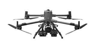
DJI Matrice 400, the enterprise flagship drone platform, boasts an impressive 59-minute flight time [1], a payload capacity of up to 6 kg [2], and integrated rotating LiDAR and mmWave radar for power-line-level obstacle sensing. It also supports the O4 Enterprise Enhanced Video Transmission and Airborne Relay Video Transmission [4], ensuring safer handling and easier operations. Combining Smart Detection with visible and thermal imaging, AR projection, ship-based takeoff/landing, and advanced automation, Matrice 400 excels in emergency response, power inspections, mapping, and AEC.
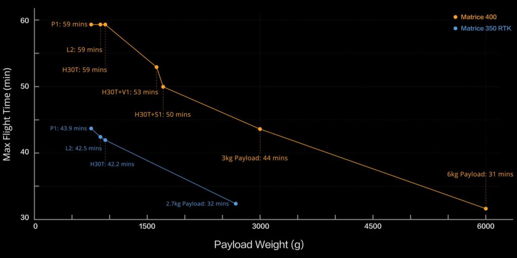
Matrice 400's flight capabilities are outstanding, offering up to 59 minutes of forward flight time even with a payload, and up to 53 minutes of hovering duration [6]. These capabilities make it a reliable tool for long-duration and continuous operations such as search and rescue, firefighting, and large-scale mapping. It can also avoid large obstacles [3] like buildings and mountains at flight speeds of up to 25 m/s.
Matrice 400’s strong payload capacity allows it to easily meet the demands of a wide range of applications. With a maximum payload capacity of 6 kg, Matrice 400 supports seamless switching between a single downward gimbal [8] and a dual downward gimbal. It also features a third gimbal connector on the underside for additional flexibility. The aircraft is equipped with 4 external E-Port V2 ports [7], enabling simultaneous mounting of up to 7 payloads.
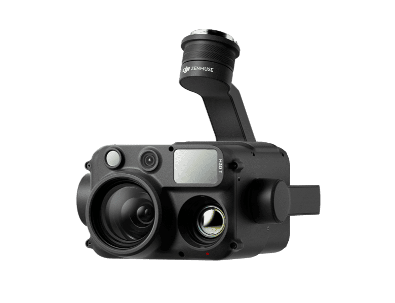
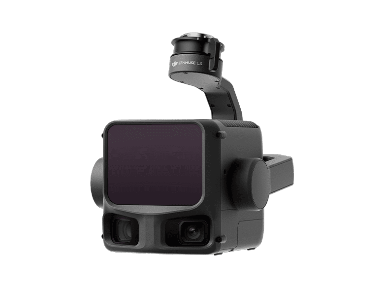
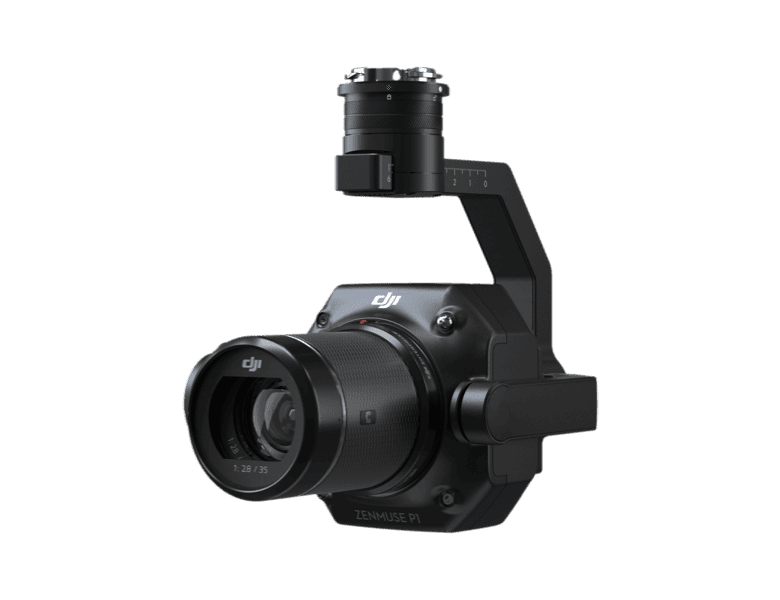
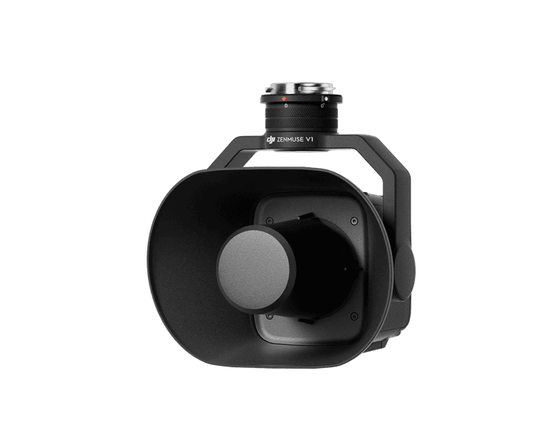
Depending on the task, Matrice 400 can be equipped with the Zenmuse H30 Series, L2, P1, S1 Spotlight, V1 Speaker, Manifold 3, or third-party payloads, thereby expanding its capabilities and unlocking the full potential of the DJI ecosystem.


IP Rating
Operating Temperature
During tasks such as power grid inspection, the obstacle sensing system automatically detects frontal wire obstacles and displays easily recognisable AR lines on the remote controller’s screen, making the surrounding environment clear at a glance and ensuring safer flight.
When operating during the day or night in urban regions, the remote controller can display the names of buildings and landmarks in real-time, marking core roads with prominent lines.
Real-time route preview is available for the drone during RTH, obstacle sensing, and FlyTo operations. During landing, the AR Aircraft Shadow can be displayed to help operators confirm the landing location.
Without modeling, you can mark points on the remote controller screen to obtain subject locations, draw lines to measure distances between multiple points, and outline areas to calculate their size. Measurement results can be synchronized to the DJI FlightHub 2 to enhance team efficiency.
Activate cruise control mode to pilot the drone in a specific direction without constantly pressing the control sticks, making long-distance flights or linear inspections easier.
In emergencies or disasters, the drone can automatically adjust its flight path and speed based on the surrounding environment, allowing it to reach a designated location without manual adjustments.
Smart Track allows for precise subject positioning and automatic zoom adjustments, allowing you to switch between subjects easily. It can automatically reacquire a subject even if obscured briefly.
POI enables continuous observation and 3D modeling of buildings while orbiting a designated area, greatly enhancing the efficiency of fixed-point observation and modeling tasks.
When equipped with the L2 LiDAR system, Matrice 400 can perform automated power transmission and distribution line following flights. It uses the rotating LiDAR to detect obstacles in real time and automatically bypasses crossing lines.
Matrice 400 supports the planning and execution of slope and geometric routes via DJI Pilot 2 or DJI FlightHub 2. Whether conducting detailed aerial surveys of building facades, slopes, or other inclined surfaces, or collecting mapping data of individual buildings or structures, Matrice 400 can quickly plan slope or geometric routes to efficiently acquire high-precision data.
DJI RC Plus 2 Enterprise Enhanced Remote Controller features a new high-brightness screen that remains clearly visible even in direct sunlight. It has an IP54 protection rating and can operate in temperatures ranging from -20° to 50° C (-4° to 122° F). Equipped with the O4 Enterprise Enhanced Video Transmission, it features a built-in high-gain antenna array, providing strong performance. It also supports the sub2G module and 4G hybrid transmission solutions, ensuring stable and smooth video feeds in both urban high-rise and mountainous environments.
The DJI Cellular Dongle 2 offers 4G network video transmission and can work together with the O4 Enterprise Enhanced Video Transmission System, ensuring safe flights in complex environments. Additionally, it provides mobile network connectivity for the remote controller.
The TB100 Intelligent Flight Battery uses high-performance, high-energy cells and can be charged up to 400 cycles, reducing the cost per flight. It also features enhanced heat dissipation and is equipped with a self-heating system for improved reliability.
The TB100C Tethered Battery is compatible with third-party tethered lighting and communication products, enabling long-duration aerial lighting and communication base station functions via cable. Reserved ports are available to support third-party development of automated recharging station products, such as drone docks.
The intelligent battery station is a one-stop solution for battery charging, storage, and transport. It can charge up to three TB100 batteries and two WB37 batteries sequentially. With a fast charging time of just 45 minutes [18] per TB100 battery, it ensures seamless, uninterrupted flight operations. In Silent Mode, noise levels are as low as 36 dB [19].
The D-RTK 3 Multifunctional Station can serve as a base station to provide centimeter-level positioning for multiple drones simultaneously. Additionally, the new Rover Station Mode, combined with the DJI Enterprise app and DJI Terra, provides a comprehensive solution for high-precision aerial surveying applications, ensuring accurate operations.
Specifically for the Matrice 400, DJI FlightHub 2 has been upgraded to enable cloud-based remote control, allowing operators to control the aircraft’s flight attitude and official payloads, as well as to perform remote takeoff, landing, and Live Flight Controls. In addition, it supports a wide range of flight route planning functions, including slope routes, geometric routes, and other advanced route types. During multi-drone operations, operators can remotely synchronise and display multiple livestreams across screens, creating a new, efficient air-ground integrated operation experience.
* Users who purchase Matrice 400 and bind it to FlightHub 2 upon activation will receive allocated live streaming minutes, map imagery quotas, and cloud storage space.
DJI Terra is a 3D model reconstruction software that has photogrammetry as its core technology. It supports accurate and efficient 2D and 3D reconstruction using visible light data, as well as point cloud data reconstruction and processing with DJI Zenmuse L2. DJI Terra is an ideal match for DJI Matrice 400 and its payloads. It works in conjunction to build a complete application solution that caters to vertical scenarios such as land surveying and mapping, power line inspection, emergency response, construction, and forestry.
DJI Modify provides intelligent 3D mesh and point cloud model editing. When paired with the Matrice 400 and DJI Terra, it can create an integrated solution covering aerial surveying, modeling, model repair, and sharing.

Comprehensive Protection | Professional Quality Assurance | Exclusive Service | Service Starts
with Activation
Free Repairs
Unlimited number of free repairs within the coverage limit
Battery Replacement
2 batteries per year, long-lasting runtime
Coverage for Your Whole Fleet
Shared limit for maximum protection
Free Shipping
Free Mail-in Repairs, Hassle-Free Service
Expert Service
Rapid response from DJI product experts
Full Device Coverage
Worry-free support for every mission
In addition to the official warranty, an extra 1-year warranty extension is provided. Major parts
are covered by the official warranty, with support provided by DJI's professional engineers.
Official Service
Supported by professional engineers
Quality Repairs
Original parts, guaranteed quality
* Always check and strictly abide by local laws and regulations before flying.
** All data on this page was collected with a production model of DJI Matrice 400 in a controlled test environment. Actual experience may vary depending on the environment, usage, and firmware version.
*** All videos and photos on this page were shot in strict compliance with local laws and regulations. Demos, including wildlife, were shot from a safe distance and are used for reference only. Please observe local laws and regulations and ensure the aircraft has obtained relevant certifications before flying.
**** Before use, Matrice 400 must be activated via the DJI Pilot 2 app.
1. Measured with the aircraft flying forward at a constant speed of 10 m/s in a windless environment at sea level, carrying only the H30T (total weight 10,670 g), and from 100% battery level until 0%. Data is for reference only. Actual experience may vary depending on the environment, usage, and firmware version.
2. The 6 kg payload is measured at the third gimbal connector under sea level conditions. Payload capacity decreases as altitude increases. For details, refer to the official user manual.
3. Power line obstacle sensing capability: When directly facing a transmission line (21.6 mm steel-core aluminum stranded wire), obstacle sensing is supported at speeds up to 25 m/s. When both transmission lines (21.6 mm steel-core aluminum stranded wire) and distribution lines (12 mm steel-core aluminum stranded wire) are present, obstacle sensing is supported at speeds up to 17 m/s. Obstacle sensing performance may vary depending on environmental conditions (such as cloud, fog, rain, or snow), as well as the material, position, and shape of the target object. Due to the limitations of the safety system, the aircraft cannot actively avoid fast-moving objects; please fly with caution in such environments. Refer to the user manual for more information. The mmWave radar function is unavailable in some countries/regions.
4. This feature is unavailable in countries or regions without 5GHz frequency support. Refer to local laws and regulations for more information.
5. Operating frequency allowed varies among countries and regions. Refer to local laws and regulations for more information.
6. Measured with the aircraft hovering in a windless environment at sea level, carrying only the H30T (total weight 10,670 g), and from 100% battery level until 0%. Data is for reference only. Actual usage time may vary depending on the flight mode, accessories, and environment.
7. The E4 port of E-Port V2 can be expanded into four payload ports via the E-Port Hub expansion plate. For more detailed information, visit https://developer.dji.com/payload-sdk to learn more.
8. Sold separately.
9. Please follow the requirements stated in the IP55 protection rating instructions. Measured in a controlled environment. The IP rating is not permanently effective and may decrease due to product wear and tear.
10. Measured with FCC compliance in an unobstructed environment with low interference at a flight altitude of approximately 120 m. Data is for reference only. During your flight, please pay attention to reminders in the app.
11. To use 4G Enhanced Transmission, the remote controller must be equipped with the DJI Cellular Dongle 2 (sold separately) or connected to the internet via Wi-Fi. This service is not available in some countries and regions. Please consult your local dealer for details.
12. There are certain blind areas of visual sensing and infrared sensing. Positioning and obstacle-sensing performance may be affected by the flight environment and obstacle characteristics. Please fly with caution.
13. When ambient light is below 12 lux, the visual sensor switches to black-and-white mode.
14. Zenmuse H30 Series required.
15. DJI FlightHub 2 required.
16. It is recommended to use the feature when the ship speed is below 10 knots and the wind speed is below 5 m/s; exercise caution in other environments. It is recommended to reserve a 3 m × 3 m takeoff and landing space on the deck. Standard landing point pattern files are available on the download page.
17. The following accessories are all compatible with Matrice 400.
18. Charging time is measured based on a 220-volt voltage.
19. Measured in a controlled environment. Results may vary depending on the environment, actual use, and firmware version.
20. Service offerings may vary by country or region. For details, please consult your local dealer. Free Repairs: Get free repairs within the coverage scope and amount; Coverage for Your Whole Fleet: Shared coverage can be extended to other DJI Enterprise devices bound to DJI Care Enterprise Plus within the same time period (30 calendar days) after the first activation and binding; Free Shipping: Available in regions covered by DJI Care Enterprise. Users are responsible for additional costs including logistics and customs duties incurred beyond the scope of coverage. The official extended warranty covers the following components: aircraft body, intelligent battery station, remote controller, single downward gimbal module, dual downward gimbal module, and third gimbal connector.
Get the support you need. From choosing the right drones to getting professional training, our experienced drone consultants ensure that all your needs are met.