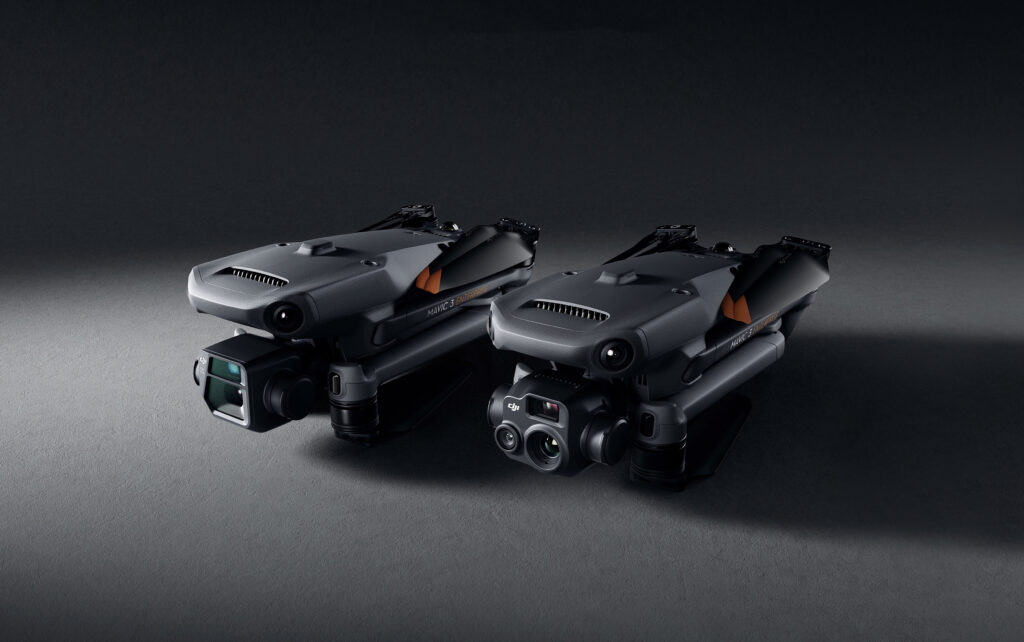

“The Mavic 3 Enterprise will prove to be an extremely valuable and beneficial tool for environmental and wildlife protection, construction, surveying, energy, public safety and countless other fields”.
Christina Zhang, DJI’s Senior Director of Corporate Strategy DJI Tweet
DJI Mavic 3E: The Mavic 3E is primarily intended for efficient mapping and surveying operations, with improved performance in low-light conditions. It boasts efficient performance without the use of Ground Control Points. The following are the key features of the DJI Mavic 3E:
The DJI Mavic 3E works in conjunction with DJI’s mapping software – DJI Terra, for all stages of work; from mission planning to processing of 2D and 3D models.
DJI Mavic 3T: The Mavic 3T is designed for aerial operations, specifically in firefighting, search and rescue, inspection and night operations. The standout feature of this drone is its thermal camera, which supports area temperature measurement, high-temperature alerts, colour palettes, and isotherms to help professionals find hot spots and make quick and better-informed decisions. The following are the key features of the DJI Mavic 3T:
The DJI Mavic 3T is designed to work with DJI Thermal Analysis Tool 3.0 (DTAT 3.0) software, which helps professionals analyse, annotate and process captured images to detect any instances of temperature abnormalities.
The M300–P1 combo remains DJI’s most powerful photogrammetry drone mapping solution, but it only caters to a niche demographic. On the other hand, the Mavic 3E is perfect for surveyors looking for a more compact and cost-effective aerial surveying option, or for those who prefer to start with an entry-level drone. Here’s a quick comparison:

The DJI Mavic 3 Enterprise is aimed at the same market as the P4 RTK, and is reportedly an upgrade on the DJI Phantom 4 RTK. Here’s a quick comparison:

Exceptional Operational Efficiency
Compatible Accessories
Comprehensive Software Suite
Finally, the DJI Mavic 3 Enterprise series is compatible with a comprehensive software suite to make the most of the acquired data:
Open Development Ecosystem
PSDK or the Payload Software Development Kit lets the Mavic 3 Enterprise Series escalate their capabilities devices from outside sources (like the RTK Module, Loudspeakers). Likewise, you may directly connect the Mavic 3 Enterprise Series to third-party cloud systems using Pilot 2’s built-in MQTT-based protocols in the DJI Cloud API without developing an App; you can also access the hardware, streaming video, and photo data.
Data Security for Mission Critical Situations
Since we’re talking about missions involving sensitive data, it is crucial to manage this data as securely as possible. The Mavic 3 Enterprise Series offers advanced security features to protect the integrity of data generated during sensitive flights. For instance, activating ‘Local Data Mode’ stops the DJI Pilot 2 flight control app from sending/receiving any information over the internet. This assures added-security for critical missions that involve crucial infrastructure, governmental projects or any such sensitive missions. Likewise, the radio link between the aircraft and the remote controller features robust AES-256 encryption.
How are you finding the all-new DJI Mavic 3 Enterprise Series? The Mavic 3 Enterprise Series is literally refining industry standards for small commercial drones. If you are a professional in the Mapping, Surveying or Public Safety sector, you do not want to miss out on this invaluable asset. Drop us a line at hello@thedronecentre.ae, to learn more!