DJI's First Long-Range, High-Accuracy Aerial LiDAR System
DJI's next-generation high-accuracy aerial LiDAR system features a long-range LiDAR capable of reaching up to 950 m [1] even on objects with just 10% reflectivity. Dual 100MP RGB mapping cameras and a high-precision POS system accelerate geospatial data acquisition, enabling daily coverage of up to 100 km² [2].
1535nm Long-Range LiDAR
Dual 100MP RGB Mapping Camera System
High Accuracy
High Penetration
Up to 100 km² per Day [2]
End-To-End Solution
DJI Care Enterprise
Hardware Performance Redefined
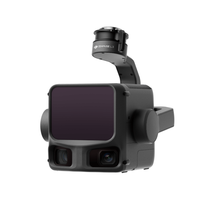
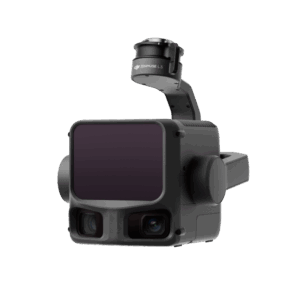
Zenmuse L3 integrates a 1535nm long-range LiDAR, dual 100MP RGB mapping cameras, a high-precision POS system, and a three-axis gimbal, all within a compact device, delivering unprecedented performance for its size.
1535nm Long-Range LiDAR
Long Range, Wide Coverage
Zenmuse L3 achieves a maximum detection range of 950 m [1] at a pulse rate of 100 kHz, tested under 100 klx ambient light and on objects with 10% reflectivity. The adjustable pulse rate allows for flexible power output and optimal adaptation to different operational scenarios. Typical flight altitudes of 300 to 500 m significantly [3] expand single-flight coverage and boost mapping efficiency.
Small Spot, High Energy
With a laser beam divergence of just 0.25 mrad (1/e²), the spot size at the same range is about one-fifth that of Zenmuse L2, enabling detection of smaller objects such as power lines and branches. Higher energy density results in stronger penetration capability, significantly increasing ground point density beneath vegetation and enabling high-accuracy reconstruction of complex terrains and structures.
High Pulse Rate, Multiple Returns
With maximum laser pulse emission frequency of 2 million pulses per second and support for up to 16 returns [4], Zenmuse L3 delivers highly accurate spatial reconstruction. Point cloud density and penetration capability can be adjusted to fit needs from high-accuracy mapping to complex environments.
Scanning Modes
Supports Linear, Star-Shaped, and Non-Repetitive scanning modes for different operational scenarios: • Linear: Achieves more consistent point cloud distribution, ideal for high-accuracy terrain mapping. • Star-Shaped: Balances accuracy with multiple scan angles and penetration capability, well-suited for forests or dense urban environments. • Non-Repetitive: Provides multiple scan angles and broader coverage, optimized for power line inspections and other complex structural surveys.
Dual 100MP RGB Mapping Camera System
Dual 100MP RGB Mapping Cameras
107° Ultra-Wide FOV
Equipped with dual 100MP 4/3 CMOS RGB sensors and a mechanical shutter, Zenmuse L3 delivers significantly enhanced accuracy and efficiency. Pixel binning supports an effective 25MP resolution with larger pixel size, producing superior color reproduction even under poor lighting conditions.
The dual RGB mapping cameras provide a horizontal field of view (FOV) of up to 107°, allowing each capture to cover a broader area. Even with a 20% LiDAR side overlap ratio, you can capture data for both digital orthophoto maps (DOM) and digital elevation models (DEM) in a single flight, thereby greatly improving operational efficiency.
Accuracy Meets Efficiency
Zenmuse L3 delivers significant improvements in both point cloud and RGB accuracy, while raising efficiency to new heights. Paired with DJI Matrice 400, a single flight can cover up to 10 km², enabling up to 100 km² of high-accuracy mapping per day [2]. Large-area, high-accuracy results are delivered in a seamless workflow.
High Accuracy
Scanning Modes
Supports Linear, Star-Shaped, and Non-Repetitive scanning modes for different operational scenarios: • Linear: Achieves more consistent point cloud distribution, ideal for high-accuracy terrain mapping. • Star-Shaped: Balances accuracy with multiple scan angles and penetration capability, well-suited for forests or dense urban environments. • Non-Repetitive: Provides multiple scan angles and broader coverage, optimized for power line inspections and other complex structural surveys.
LiDAR Data Accuracy
Vertical accuracy is better than 3 cm at 120m altitude, better than 5 cm at 300 m, and better than 10 cm at 500 m [6], easily supporting mapping projects at 1:500, 1:1000, and 1:2000 scales. The point cloud thickness produced by Zenmuse L3 is only half that of Zenmuse L2, supporting advanced analysis and high-accuracy applications.
Photogrammetric Accuracy
With dual 100MP RGB mapping cameras, Zenmuse L3 achieves a ground sample distance (GSD) of 3 cm even at a 300m flight altitude [7]. Real-time position synchronization enables operation without ground control points (GCPs), ensuring high-quality imagery for precise mapping.
High Penetration
High Ground Point Density
With a smaller laser spot and higher single-pulse energy, Zenmuse L3 offers superior penetration capability. In terrain mapping and similar applications, it captures more ground points with greater completeness, significantly improving the accuracy and integrity of terrain data for precise surface fitting and reconstruction.
High Accuracy
Up to 100 km² per Day [2]
Multiple Deliverables in a Single Flight
When mounted on DJI Matrice 400, Zenmuse L3 delivers outstanding efficiency. At a flight altitude of 300 m, a single flight can cover up to 10 km², enabling up to 100 km² of daily coverage [2].
Simultaneously captures LiDAR and RGB data to generate a range of mapping products from a single flight, including DEM, DOM, and more.
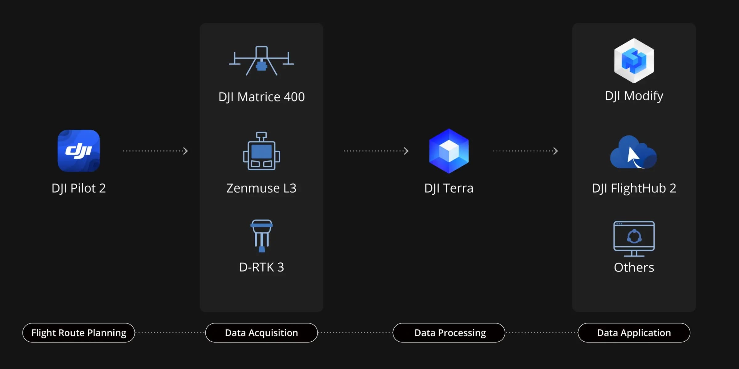
End-To-End Solution
Zenmuse L3 seamlessly integrates with DJI’s ecosystem to deliver an end-to-end mapping solution. From data acquisition and processing to application, this unified workflow is simpler to operate and easier to master than traditional multi-platform setups, helping users efficiently complete a wide range of mapping tasks.
Data Acquisition
Point Cloud Result Preview
Power Line Follow
Flexible Split-Screen View
Real-Time Point Cloud
Cloud-Based Point Cloud Measurement
DJI Pilot 2 automatically recommends flight parameters based on user-defined routes and generates a Density Profile Chart and point cloud distribution charts before takeoff, enabling users to preview point cloud results.
Zenmuse L3 significantly enhances Power Line Follow, supporting operations up to 130m altitude. Without bypassing obstacles or crossing lines, Zenmuse L3 enables complete electrical corridor data acquisition in a single straight flight in most scenarios.
DJI Pilot 2 supports split-screen viewing of any two data sources—point cloud, RGB, or Vision Assist—allowing users to freely combine displays to suit their needs. During Power Line Follow or when the RGB cameras face downward, Vision Assist provides real-time forward-facing visuals, reducing flight risks and improving overall efficiency and safety.
Supports real-time point cloud SLAM reconstruction with instant 2D and 3D point cloud previews during operations, allowing users to monitor progress and take measurements as data is being collected. Point cloud results can also sync instantly to the cloud via DJI FlightHub 2 for rapid emergency response and assessment.
Zenmuse L3 point cloud outputs are fully compatible with DJI FlightHub 2. Users can view and manage point cloud data in real time, easily generate detailed flight routes, annotate and share points of interest, and perform advanced line and area measurements directly in the cloud.
Data Processing
PPK Data Processing
LiDAR Gaussian Splatting
Fusion-Based Modeling
DJI Terra features robust built-in PPK (Post-Processed Kinematic) capabilities, compatible with D-RTK 3 and standard base station data. The platform supports local PPK for RGB imagery and LiDAR, providing centimeter-level positioning accuracy even in areas with limited network connectivity or where RTK is unavailable.
DJI Terra enables advanced Gaussian Splatting fusion-based reconstruction of point cloud and RGB data collected by Zenmuse L3, dramatically enhancing the realism and detail of 3D models. This capability broadens the application scope of LiDAR across diverse mapping scenarios and delivers higher-quality 3D model outputs.
DJI Terra enables deep integration of LiDAR and RGB data. With a single acquisition, users can simultaneously generate high-accuracy point clouds, 2D maps, and 3D mesh models. This data fusion approach significantly enhances model completeness and detail, especially in environments with complex structures such as bridges and substations. It meets the needs of industries including energy, transportation, and infrastructure.
Data Application
Smart Filter
Profile Tool
Comprehensive Output Capabilities
DJI Modify supports intelligent semantic classification of point clouds, automatically distinguishing ground, vegetation, buildings, wires, electric towers, and more. After classification, users can efficiently adjust categories using Quick Selection and Structure Selection tools, further enhancing classification accuracy and processing efficiency.
DJI Modify’s Profile tool allows users to flexibly select cross-sectional areas of point cloud models for intuitive analysis of terrain variation, structural features, and elevation profiles.
When paired with DJI Modify, Zenmuse L3 delivers versatile outputs. DJI Modify automatically generates a wide range of mapping products from point cloud data—including semantic point clouds, DEM, TIN, point grids, and contour lines—and supports multi-layer visualization. These outputs meet the diverse needs of engineering and design CAD-related workflows.
End-To-End Solution
Delivers a complete workflow covering data capture, processing, and application.
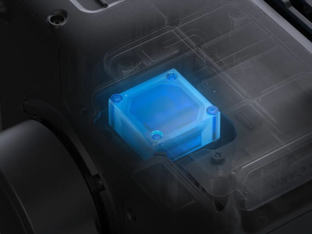
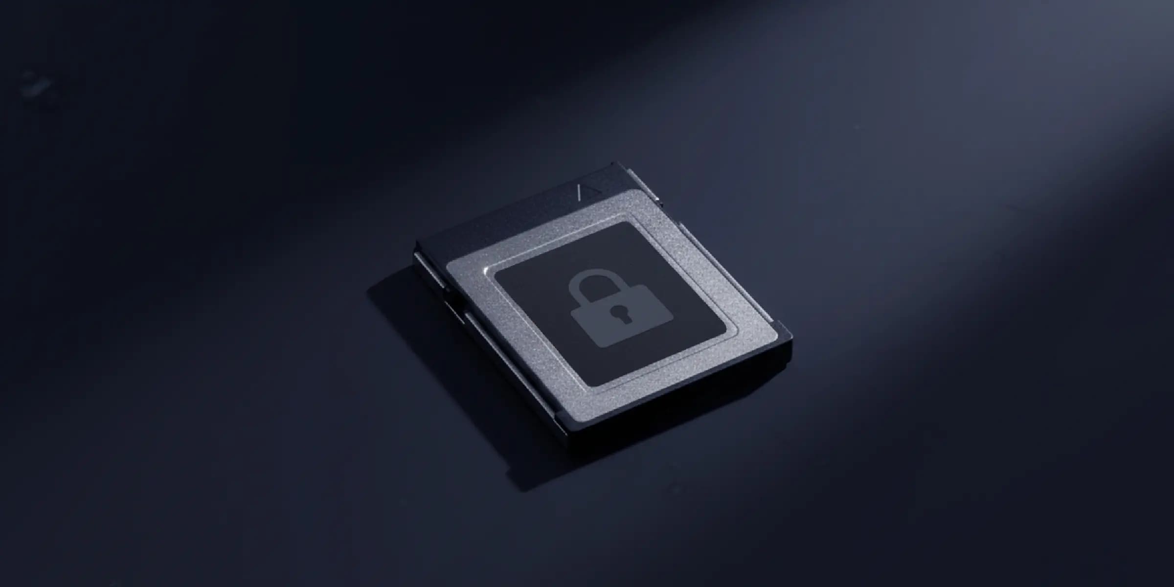
Data Security
Zenmuse L3 supports CFexpress™ memory card encryption, enabling secure protection of stored data and preventing unauthorized access or data theft. Matrice 400 offers one-click log clearing and AES-256 encryption for video transmission, further ensuring data confidentiality.
1. a. Range Definition: The range is defined as the distance at which 50% of the emitted laser pulses are detected. If a laser beam hits more than one subject, the total laser transmitter power is split and the achievable range is reduced. b. Test Conditions: 100 klx ambient light, within the central area of the FOV, using a flat subject with a size larger than the laser beam diameter, a perpendicular angle of incidence, and an atmospheric visibility of 23 km. c. The maximum detection range is 900 m by default. For a longer range, contact DJI support or an authorized dealer.
2. When paired with DJI Matrice 400, Zenmuse L3 can achieve a daily mapping coverage of up to 100 km² (flat terrain, 300m nadir flight altitude, 20% side overlap, 17m/s flight speed, and a total effective flight time of 6 hours).
3. The flying altitude limit varies in different countries or regions. Make sure to fly at the altitudes outlined by local laws and regulations.
4. Support for 16 returns is limited to laser pulse emission frequency of 100 kHz and 350 kHz.
5. Tested at 150 m under ambient temperature of 25° C (77° F) and 80% object reflectivity. Actual results may vary depending on environmental and operational conditions. Data is provided for reference only.
6. Measured under the following conditions in a DJI laboratory environment: a. The field contained objects with obvious angular features. DJI Matrice 400 was linked to a position-calibrated D-RTK 3 Multifunctional Station. The flight route was planned using DJI Pilot 2’s Area Route (with Calibrate IMU enabled) with Linear scanning. The flight speed was set to 15 m/s, gimbal pitch to -90°, and each straight segment of the flight route was less than 3300 m. b. Using exposed hard ground checkpoints that conformed to the diffuse reflection model. c. DJI Terra was used for post-processing with Optimize Point Cloud Accuracy enabled.
7. For detailed calculation methods, refer to the user manual available on the Downloads page of the official DJI Zenmuse L3 webpage.
8. The service plans offered in different countries or regions may differ. For more information, please consult your local authorized dealer. Free Repairs: Get free repairs within the coverage scope and limit; Coverage for Your Whole Fleet: Shared coverage can be extended to other DJI Enterprise devices bound to DJI Care Enterprise Plus within the same time period (30 calendar days) after the first activation and binding; Free Shipping: Available in regions covered by DJI Care Enterprise. Users are responsible for additional costs including logistics and customs duties incurred beyond the scope of coverage. For specific coverage of components, refer to the After-Sales Service Policy under Support on the DJI official website.
Ready to Fly Yet?
Get the support you need. From choosing the right drones to getting professional training, our experienced drone consultants ensure that all your needs are met.
Request for a Quote
Please fill up the form to get your Quote for the Zenmuse L3.