LiDAR stands for Light Detection and Ranging, and it is a remote sensing method that uses the light from a laser to collect measurements. To be precise, LiDAR works by sending light pulses to the object on the earth’s surface – and the amount of time it takes to return to the source indicates the exact distance of the object (time of flight).
The LiDAR sensor employs a GNSS receiver, an IMU, and a Laser Scanner to build a three-dimensional understanding of an object. The GNSS receiver helps us locate the object’s position; the IMU unit tracks the speed and orientation of the drone as it flies; and the laser scanner gives us the distance. Once a LiDAR system collects this data, specialised 3D mapping software processes this information along with Global Positioning System (GPS) and Inertial Navigation System (INS) data to produce intricate and precise 3D models of natural and man-made objects such as buildings, bridges and other infrastructures.
The LiDAR system accurately measures vegetation location, density, and the underlying ground topography. It is also used in Archaeology, Climate Monitoring, Urban Planning, Right of Way Surveys in Power & Utilities, Mining, Energy sector, and more.
A LiDAR drone, as the name suggests, is a Drone equipped with a LiDAR payload. LiDAR drones yield the highest fidelity data compared to other aerial survey methods. For example, the point cloud generated from drone-based LiDAR can yield 100–500 points per square metre at a vertical elevation accuracy of 2–3 centimetres. In addition, the latest advancements in LiDAR technology have drastically reduced the cost and size of LiDAR sensors, making them compact enough to be incorporated with a drone; fostering easy access to LiDAR solutions across various sectors.
Now, the that question remains: Why use Drone-powered LiDAR over ground-based?
Both air and ground LiDAR systems are indistinguishable in terms of accuracy. But, the real distinction is when you compare their efficiency. Compared to the tedious ground-based LiDAR methods, flying a LiDAR drone over the survey site allows you to speed up your data-capturing process while enabling access to hard-to-reach areas.
LiDAR lends itself to many industries – from land surveys, Right of Way surveys to even asset inspections, LiDAR data is crucial to many industries like Power & Utilities and telecom. And the future looks even brighter! As per the Global LiDAR Drone Market Report, the LiDAR drone market size will reach US$ 892.0 million by 2032, that too with a Compound Annual Growth Rate of 15.9% through 2033.
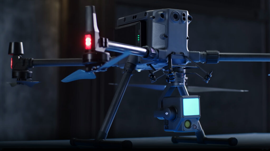
DJI’s first Livox LiDAR payload — the DJI Zenmuse L1- is gaining much traction among drone professionals. It incorporates the power of laser and visible light, allowing you to capture both LiDAR and Photogrammetry data simultaneously.
L1 comes integrated with the Livox LiDAR Module; It combines an accurate IMU system, a survey grade RGB sensor, and of course, the LiDAR sensor— balanced by a 3-axis stabilised gimbal. While other payloads may display basic point clouds in real time, the L1 gives you a real-time true-colour point cloud. This translates to quick insight for the operators while on the site, enabling them to make instantaneous decisions in mission-critical situations. You can even use this feature to ensure the integrity and effectiveness of the captured data while still on the field.
Being IP54-rated, the L1 doesn’t hold you back when the weather gets uncooperative – in snow, fog, or even light rain. If you are an L1 user already, here you go – Here is an exclusive Guidebook from DJI to help you optimise your operations with the DJI Zenmuse L1. This comprehensive document covers everything you need to know about this incredible tool – from specs and settings to scenario-specific parameters to use, payload calibration, mission planning, and data processing with DJI Terra.
DJI Zenmuse L1 can be utilised for:
If you are looking for a Safer, Faster, more Cost-efficient and Effective LiDAR Drone solution for your Surveying and Mapping efforts, the DJI Zenmuse L1 is the right payload for you. Would you like to learn more? Feel free to get in touch with us today!